

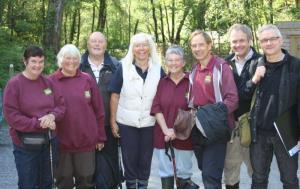
 Across the East Dartmoor National Nature Reserve, the
History Hunters, a team of dedicated volunteers is hard at work uncovering the
stories of the past using the clues left behind by our ancestors. Albert Knott
of Natural England is the facilitator of the History Hunters who have been
mapping and recording the remains of ancient leats, mines, farms and fields of
Yarner Woods and the Bovey Valley. But now the advance of technology has given
them a huge boost, opening up many new tracks of discovery.
Across the East Dartmoor National Nature Reserve, the
History Hunters, a team of dedicated volunteers is hard at work uncovering the
stories of the past using the clues left behind by our ancestors. Albert Knott
of Natural England is the facilitator of the History Hunters who have been
mapping and recording the remains of ancient leats, mines, farms and fields of
Yarner Woods and the Bovey Valley. But now the advance of technology has given
them a huge boost, opening up many new tracks of discovery.
Until recently the files on local archaeology contained only 24 Historic Environment Records (HERs) including the Boveycombe Farmstead in Hisley Wood, but with the introduction of LiDAR a new rush of information has now revealed around 300 HERs in the area. Aircraft mounted LiDAR is an exciting recent development that uses reflected light beams to create an accurate relief map of the ground surface. This forward step in technology funded as part of the Moor than meets the eye Landscape Partnership has produced a giant leap in the discovery of historical features on the ground. Humps, bumps, walls and earthworks have all become visible, creating a flurry of activity for the History Hunters as they update their records; locating, measuring, mapping and photographing the evidence. Previous attempts to map local features have been inconsistent as Donn’s Map of the 18th century and the 19th century Tithe Map show many discrepancies, so now is the time to record a comprehensive and accurate set of HERs in this Dartmoor valley.
At a review meeting in October the team got together to explain their work to an assembled audience comprising archaeologists and local archivists. After an initial introduction by Reg Lander the day continued with a walk through the tangled undergrowth of Hisley Wood to see what LiDAR has uncovered. Using maps and photos Reg explained how piles of boulders among the trees were probably left behind after field clearance work in years gone by. Interpreting bumps on the ground is a skill that is honed by experience and History Hunters Liz, Janet and Caroline have used the LiDAR results to find open tin workings, ridge and furrow agricultural systems and a mound linked by a causeway which is probably a very old feature. With all these finds there are now more questions than answers but the exciting discoveries have not stopped there. The volunteers have found a series of large boulders on top of a prominent mound in the lower part of the valley and their research is telling them it could be a Bronze Age burial site. Having cleared away brambles there is no doubt that these boulders have been intentionally placed together so the History Hunters’ job is to record them for verification by Dartmoor National Park archaeologists. Barry and Tanya are also part of the team and have shared their skills to undertake detailed survey work to record and produce hand-drawn scale maps of these interesting features that accurately show terrain, textures and materials. Chris is another member of the team who uses the plans and other information to illustrate how the feature would have looked. The depth and breadth of the volunteers’ skills and use of technology will result in a meaningful record of the last 4,000 years in the valley. The archaeologists now have their work cut out!
During the afternoon the tour continued, starting in the “potato field” at Boveycombe Farm and looking at the boundaries and tracks that were last used in the mid-20th century. The walk continued uphill to look at more ancient field systems and boundaries known as reaves. The volunteers pointed out an indistinct ridge that was just visible. It was another of the newly discovered field boundaries and an interesting discussion then followed while the woodland trees and plants were also studied. On one side of the ridge ancient oaks over-stood clusters of holly growing from seeds dropped by roosting pigeons. On the other side, a more open network of younger coppiced hazel and birch trees hinted at a previous agricultural use, demonstrating a clear distinction of previous crop and timber production. Not only will this information be useful for the Dartmoor National Park archaeologists but Natural England and the Woodland Trust will be able to understand and protect the heritage alongside the woodland conservation work. It’s a great example of partnership working, proving that careful conservation of wildlife and history can go hand in hand.
by Matt Parkin
Last update: 03 Dec 2015 10:44am